El Cochinito dropped me off at LAX, and snapped this photo of me. I’m all ready for my big adventure, everything I need for the next five days and four nights is packed in these two panniers, and my bike helmet dangles from one of the straps. A few months in the planning, this trip all started with a search for flights from Los Angeles to Colorado Springs so I could attend my nephew’s wedding. When I saw that the fare to Colorado Springs from L.A. would be at least double the fare to Denver, it was not a complete surprise, and I started to think I would just fly to Denver and rent a car.

But wait, why rent a car? Just how far is it from Denver to Colorado Springs? Wouldn’t that be a bikeable distance? Wouldn’t that be fun?! Could I bike it in one day? As soon as I saw that the ride would be around 65-75 miles, depending on where in Denver I started from, I began looking into bike shipping and other logistics.
I checked Bike Flights, and learned that the cheapest option is $41 each way, and I would have to pack and ship my bike off the Friday before Memorial Day weekend in order for it to get to Denver in time. Plus I would need to learn how to pack the bike for shipping and re-assemble it on arrival. And again for the trip back to L.A. And I haven’t done that in over 20 years. I’d rather pay a bike shop to do that for me, but most places charge $65-$90 for that service. Yikes! Multiply that times 4, and, well, that’s ridiculous.
So then I looked into renting a bike. There are shops in Denver that rent bikes, but most are either carbon road bikes that can’t take a rack for carrying panniers, or some kind of city bike that would not be suitable for a 70-ish mile ride. And the rental cost would add up after four days, to $230. Although I’d rather spend the money on a bike rental than a car rental, I’m still not sure I want to spend that much for a bike ride that might not be comfortable when I’m going that distance.
Then I remembered that, as a grad student, Nashbar had been my savior, offering affordable bikes that were great for touring. I decided to see what they had. Holy moly! I found that Nashbar had a woman’s road bike on sale for $419, and a touring bike on sale for $699! I read through the specs and the reviews, and found them encouraging.
The obvious next step was to begin the necessary justifications and rationalization. I go to Denver at least once a year, and always want a bike while I’m there. Last time I had to walk a mile (in the cold & snow!) to get from my brother’s house to the nearest bike share station. I’ve been itching to ride a bike in the Colorado Rockies again, just like in the glory days of my youth. For less than the cost of two multi-day bike rentals, I could own a bike that stays in Colorado. See? That didn’t take long! The rule of n+1 wins again!
I spent several of my evenings on Google Maps and checking Colorado biking web sites to plan my route. I ordered a kindle book on road biking in Colorado. The ride certainly looked doable, with bike trails for a good bit of the way, both heading out of Denver and again into Colorado Springs. There appeared to be this one stretch of about 10 miles in the middle of the ride where I’d have to ride on Highway 105, and I wasn’t sure what that would be like. I searched for blog posts or discussions about biking between Denver and Colorado Springs, and was disappointed to find very little on this. You would think others have done this many times. Is this a bad sign?
I came across one discussion that was not encouraging. Back in 2012, someone had put the question out there about planning to bike from Denver to Colorado Springs and back for a weekend trip. The discussion resulted in the Someone deciding to take Highway 73 into Franktown, and approach it that way. He did the ride, and posted afterward that it was not a good idea. The road was heavily trafficked with trucks and had no adequate shoulder to bike on.
I asked, in the same thread, if anyone had any updates now that several years had passed, as I was planning to follow the route Google Maps suggested, using 105 after Castle Rock and before Palmer Lake. I also found a YouTube video of a motorcyclist riding Highway 105. I could see that it is a pretty ride, and that it is, indeed a road with no shoulder.
I was happy to learn that my son, who lives in Seattle these days, would be making the trip to Colorado for the wedding. El Cochinito had to stay in L.A for graduation at the school where he teaches, and other other adult children couldn’t get away for the trip either. But my son, who bikes all the time to get where he needs to go, is not the type to be interested in a 70-ish mile bike ride, and so it became clear that I would be doing this trip solo. At least I wouldn’t have to worry about something awful happening to him on Highway 105. When you’re a mom, it’s hard not to think that way.
I then checked with my brother, who lives in Denver, to see how he felt about the idea of me keeping a bike in his garage. He was quite receptive to the idea. So that was it: I would be buying a bike, my “Colorado bike”. I contacted Cycleton, the bike shop that is closest to the Denver airport, and also not too far from my sister-in-law’s place, and made arrangements for them to receive and assemble my new bike. Then I called Nashbar and got a helpful consultation on the decision between the woman’s road bike and the touring bike. Of course, the touring bike was a better fit for my needs.
As it turned out, the weekend of my nephew’s wedding just so happens to be official Bike Travel Weekend, a creation of the Adventure Cycling Association. It’s all about encouraging folks to get out and enjoy a weekend adventure by bicycle. Bike packing is a thing, after all, and figuring out how to plan the logistics for such a trip can be understandably intimidating to one who hasn’t yet done it. Adventure Cycling encourages people to share their ride plans on the web site, and help others find rides they can join. I decided to sign up with them (there is a drawing for a free bike, after all), even though I didn’t really want to advertise that I would be a woman biking alone on this trip). And I wasn’t bikepacking to go camping or do something like that, I was just getting myself to a wedding and spending my weekend at a hotel. But, hey, they sent me a sticker!

Because I’d signed up with Adventure Cycling, I started receiving emails encouraging me to make use of their resources to help support my trip planning. They offered “advisors”, folks in a variety of geographical regions who’d volunteered to provide guidance and answer questions for others planning their trips. I saw a woman’s name listed as an advisor in Colorado Springs, so I decided to ask her about my route plan and whether I should consider an alternative to Highway 105. Maybe I should consider passing through Larkspur instead? Debbie wrote back and said she’d ridden that stretch of Highway 105 several years ago and found the drivers to be quite considerate, but offered to check with a friend who might know more about it. She wrote back and confirmed that this was the way to go, and so I stuck with my plan.
A full two months before the trip, I started making my list and thinking through all that I would need to take. I coordinated the timing of the bike purchase with the bike shop that would be receiving and assembling it. I ordered bottle cages, a saddle bag and tool kit for the new bike. I planned my outfits for the five-day trip, making sure I was minimizing the bulk and that it would all fit in my two panniers. Ah, and I remembered that I would need to take with me the special magnets that attach to the rear rack to secure my Thule panniers.
As the trip drew closer, I began to realize that so much of the joy of this trip is in the planning and looking forward to it. What if the actual ride was a let-down? But, no matter what the ride turned out to be, there was no doubt that this would be an adventure. Nothing could take that element away from my trip! I did make sure I kept up my training so that the nearly 70-mile ride, at high altitude, would be within my conditioning level. In fact, the Monday before, Memorial Day, a friend and I rode a century. It was a pretty flat ride, but we had some tough headwinds, and that turned out to be good training! By the time the trip rolled around I had been waking up each morning realizing that I had been bicycling in my dreams!
When my flight landed in Denver, my panniers and I went from the plane to the A train that connects the airport to the city. I had a patent application to file, and was able to use my time on the train to get online and take care of the filing.


My son had already arrived earlier in the day, and was with my nephew. They picked me up at the train station nearest to the bike shop, and gave me and my panniers a ride. At the bike shop, my bike was mostly ready, although there was some concern about whether my saddle had arrived (uh-oh! But they found it.), adjustments were made to the saddle height, my bottle cages and saddle bag with tool kit were put in place, the mechanic helped me get the magnets attached to the rear rack (not so easy, as the rack has skinnier rails than my other bike), and at the last minute, I remembered that I needed to purchase a lock. Once all that was sorted out, I was able to put my panniers on and take the new bike for its first test ride!

I had been unsure how it would feel to ride a 30 pound bike with 25 pounds worth of panniers, but it handled just fine and the load did not seem to be a problem. I had to get used to the bar-end shifters and the toe clips, as I’d never used the former before, and it had been 20 years since the last time I rode with toe clips.
More interesting about that first ride was the awareness that I was in my home town of Denver, but in an area that had been completely transformed since “my day”. The bike shop was in Stapleton, a new development where Denver’s airport used to be. From there, I passed through Lowry, another new development that used to an Air Force base. I was able to use bike paths and bike lanes most of the way, and that was nice, although a bit confusing sometimes when following Google Maps’ navigation. I managed to turn a 6.6 mile trip into 7.6 mile one with my missed turns and whatnot.
At one point, I was routed through Fairmount Cemetery, a place I have been to when visiting the mausoleum that holds my grandparents’ ashes. Apparently, I had not been through this part, though, as it was full of interesting old grave stones and a few historic above-ground tombs. I decided to stop and snap a portrait of my new bike, which I had decided to name “Rocky”. I don’t usually name my bikes, but this one seemed like it out to have one, as it was otherwise lacking a bit in personality. The name seemed like the obvious choice, as my hope for this bike is to be able to come back and explore the Colorado Rockies with it in future bike adventures.

I spent the evening visiting with family at my sister-in-law’s place, and then got up and left for my big adventure at 8:00 a.m. I told my relatives I expected the 69-mile ride to take me 8 hours. My goal was to arrive at the hotel in Colorado Springs by 4:00, allowing plenty of time to shower and get cleaned up before family gathered for dinner at 5:30.

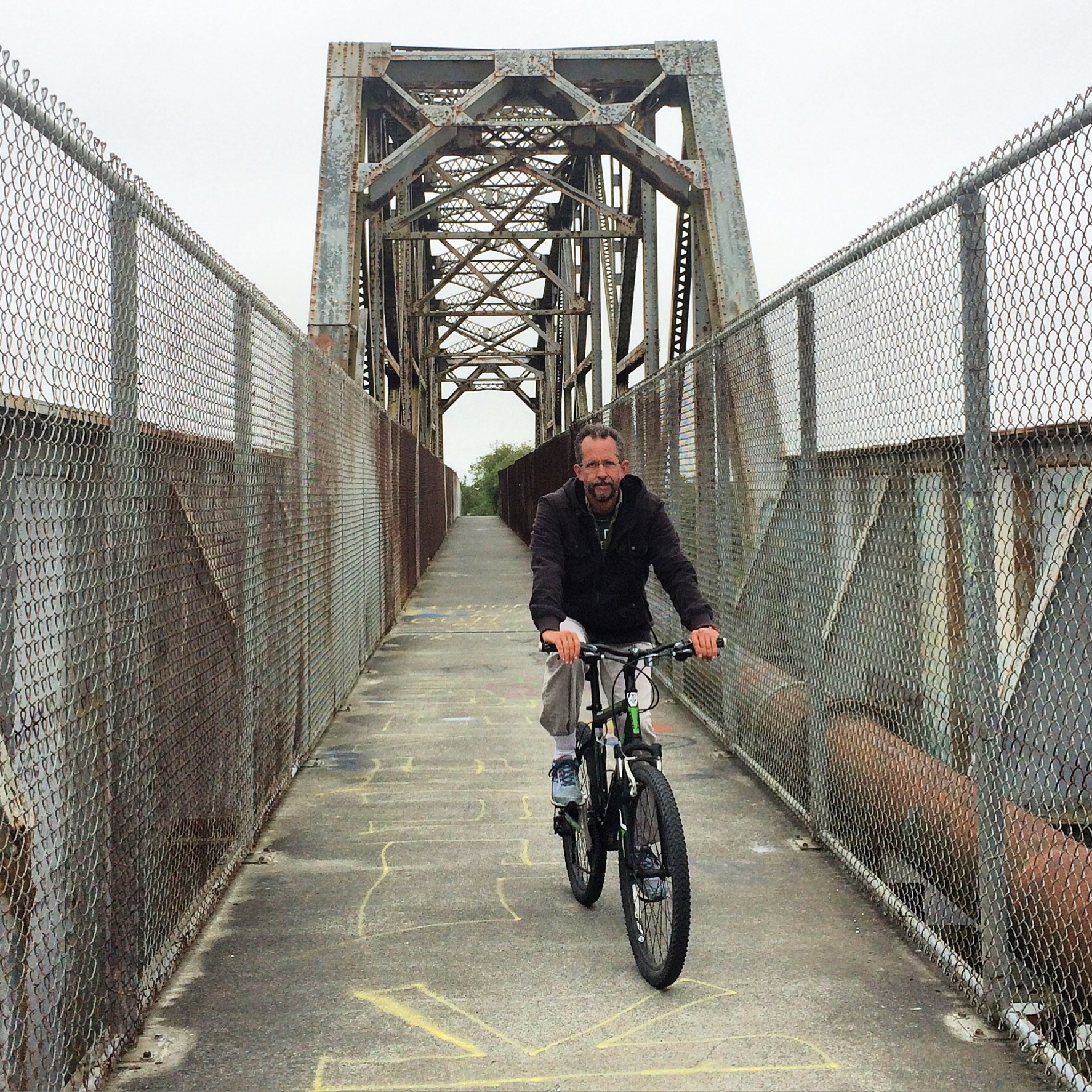
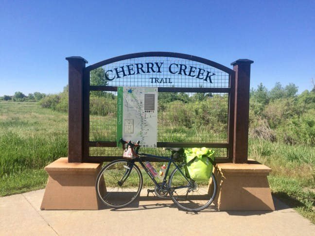
The ride started out lovely, first on the High Line Canal, and then, well, only about 15 minutes into my ride, I already missed a turn! It was sunny and warm, so I decided to stop and take off the long sleeved shirt I had on over my Nuu-Muu dress and WABA jersey. At this point, I also double-checked the directions to make sure I got back on the correct trail. It was time to cross a bridge and get on the Cherry Creek Bike Path. I love bridges, so I snapped a photo of my bike on the bridge. Thus began a cheerful meandering along the bike path. Google Maps was predicting I would get there by 3:30 p.m. I knew I needed to allow more time than that for pits stops and lunch, but it just seemed like I had gobs of time — all day, in fact — so why not enjoy the experience and take photos whenever I wanted?

I marveled at the bike route. I took delight in how long I kept going, still continuing on bike paths. How lucky! How beautiful! And there was a full on rest stop and picnic area at the Arapahoe Trailhead, right along the bike path, so I took the opportunity to use the rest room. It was one of those nice ones, with toilet rooms big enough I could roll my bike right on in. No need to lock it up and worry about my panniers.
I continued on more and more trails, continuing to marvel at the beauty and how nice it was to be able to ride without car traffic like this. I stopped and snapped photos along the way. It was getting warmer still, so about 90 minutes into my ride, I stopped again at one of the many shaded benches along the trail so I could take off another layer.


Eventually, I came to the turn off from the Cherry Creek Trail to take Crowfoot Valley Road, which angles over toward Castle Rock. I was on this road for about six miles, and it seemed to be a slow and gradual incline into a strong headwind. It started out feeling a bit challenging, but I’m the type that is content to just use a low gear and keep at it, knowing I will get there eventually. But it began to feel like a never ending drudgery. I kept at it. I told myself this would not be forever. I looked forward to taking a good lunch break in Castle Rock. I was getting tired, and beginning to feel like I wasn’t making much progress. I kept at it. Finally, I got to my next turn, and soon I could see Castle Rock ahead of me, and a downhill stretch! I was excited again, and looking forward to lunch, and feeling hopeful that, after a good lunch, I’d find some renewed energy for whatever awaited me in the second half of my ride.

Riding into Castle Rock, I enjoyed being routed via an odd mixture of busy high-traffic streets (rode the sidewalk at one point) and pretty, off-road bike paths. I rode through the center of town, ever on the lookout for the right place to stop for lunch. The main street passed quickly, as did an interesting riverfront-ish area, and pretty soon I was worried I’d missed my chance. Soon I was in semi-suburbanish terrain again, but spotted a Dairy Queen that even had an adjacent outdoor play area surrounded by a metal railing. In other words, my perfect lunch stop, complete with bike parking! I suspect my food choices were influenced by how wiped out I was feeling from the long, slow climb into headwinds. I had a cheeseburger and a blizzard (ice cream treat blended with pieces of Heath candy bar).


I knew the first five miles heading south out of Castle Rock would be on a frontage road that runs alongside Interstate 25, and I had imagined the frontage road would be a relatively calm stretch before heading over to Highway 105, the 10-mile stretch of narrow road with no shoulder. Little did I know, that frontage road is the most insane and unsafe place for a cyclist I can imagine! Traffic along the frontage road was heavy and constant, there was absolutely no shoulder whatsoever, and the cars where flying past much faster than the traffic on the nearby interstate. I was scared and stressed and could not wait for it to be over. I would have walked my bike on the shoulder, but there wasn’t even a place for that. When I finally got to my turnoff for Tomah Road, I pulled off to the side and took a little break, just to collect my senses and breathe a bit.
The next four miles, I was on Tomah Road, which connected me to Highway 105. Tomah Road was better than the frontage road, but still had a lot of traffic, and not much of a shoulder. It also involved about 600 feet of climbing, and, well, I quickly regained the feeling of drudgery that characterized my experience of Crowfoot Valley Road. I felt like I had to stop several times on the way up. I began to fantasize about waving down a pickup truck and asking for a ride. I started to walk my bike on the shoulder, but the shoulder was soft, and it wasn’t working out. Finally, I crossed over to the left shoulder, where my feet were walking on the soft part, and the wheels of my bike were rolling on the edge of the pavement. I could see when cars were coming toward me, and pull farther over onto the shoulder if necessary as they passed. It wasn’t efficient, but it worked to get me to the top of that hill.

I kept hoping things would be better once I got to Highway 105. As it turned out, Highway 105 was as described: little traffic, courteous drivers, no shoulder, and pretty scenery. I saw other cyclists along this part, although none carrying panniers. Under other circumstances, I think I might have loved this ride. But the rolling hills got old. It seemed like a lot more uphill and rarely any downhill. Looking at an elevation profile of that road suggests that’s exactly right. It was another 1500 or so feet of climbing, and I had to stop a lot. I drank lots of water and my electrolyte drink. I chewed on some Cliff blocks. I kept wishing I felt stronger, but it was just plain slow going. Sometimes I would walk the last part of a hill, never sure which was slower, riding or walking. I couldn’t help but notice the time. I’d told my family I planned to get to the hotel in Colorado Springs by 4 PM. But it was past 4, and I still had at least an hour and a half to go. I texted my son to let him know I was running late. He gave me the details on where we’d be meeting for dinner, a family gathering with the wedding party that had been scheduled for 5:30.
I reached a point where I just didn’t know if I could take another hill. And then there was yet another hill. I stopped in some shade at this point, noticed a little shaking in my legs, and called El Cochinito for moral support. I got his voicemail, but just describing how I was feeling seemed to help in some small way. I got back on the bike and started pedaling again, reminding myself to just focus on the next small stretch of road, and stop worrying about the entire hill or what might lay ahead after this hill. At some point on that climb, I saw a text come in from El Cochinito: “You got this!” I knew he was right. I was miserable, but I was going to make it.
Luckily, that did turn out to be my last climb on Highway 105. I got to Spruce Mountain Road, and soon was getting on to the New Santa Fe Regional Trail. Just when I was nervous about being out of water, there was a park with a rest room and drinking fountain. Phew! And, wow, was that trail ever fun! A beautiful red gravel trail, with gorgeous scenery, and what must have been a slight downhill. I was rolling fast, and my 32 mm tires were just wide enough to handle the gravel. Occasionally, I could feel the tires shift a bit in a looser patch of gravel, but I just kept my focus and my speed, and never took a spill. After all the drudgery that preceded this part, the ride was now exhilarating! I found a new wave of energy. The latter part of the trail was rather rocky. I wasn’t sure I had the right bike for rocks this big, but again, it was kind of exciting, and I was having a blast!


The trail was about 6.5 miles, then I had to do the last 6 miles on suburban roads. There were bike lanes for most of it, and some hills here and there. Every time I had to go up hill, it felt pretty tough, but I was close enough to the end, and none of those hills was as bad as what I’d already done that day, so I was able to get through it. I was feeling the thrill of realizing that, for all it’s challenges, I was going to complete this ride!
By the time I got to the hotel, it was already 6:00! I took a quick shower and got a Lyft ride over to the restaurant. My family was relieved to see that I’d made it. I was certainly relieved that it was over! I knew one thing for sure: I was not going to take the same route back to Denver. I wasn’t 100% sure I would even ride back, especially if I couldn’t identify a suitable route that would avoid the I-25 frontage road. I figured I would give myself some time to think about it, and just enjoy the weekend with family.

Saturday we had time to go visit the Garden of the Gods. We did some hiking, went out to lunch, and then got ready for the big wedding, which was being held Saturday evening at a barn in Peyton, out in the farmlands northeast of Colorado Springs. Originally, I had thought it might be fun to bike to the wedding, but it would have been a two hour ride each way, and not on pleasant roads for cycling. Given how late we stayed at the wedding, and how drunk many of the guests were, I was especially glad I did not take my bike!


Before I could go to sleep Saturday night, however, I just had to study the maps and make my decision about my route for the ride back to Denver on Sunday. I considered just riding on the nice wide shoulder on I-25 until I got to Castle Rock. It would suck to ride alongside freeway traffic for hours, but at least I would have plenty of room. Yet I just couldn’t see doing that. I decided to take Highway 83 north out of Colorado Springs, and then take Russelville Road to Franktown. Highway 83 might be a bit trafficky, but I’d only be on it for 19 miles, and then Russelville Road would be quiet farmland, and once I got to Franktown, the rest of the way would be on the Cherry Creek Trail.
Even though I really should have gone to sleep sooner, I slept well knowing that I had my route figured out. Sunday morning, I enjoyed a leisurely breakfast with extended family, we said our goodbyes, I gave one of my panniers to my sister-in-law to take in her car, and began my journey.
Highway 83 was definitely more trafficked than Highway 105, but not too bad, and most drivers did pass with care. The good news was that, although the shoulder was narrow, there was a shoulder – always at least 8 inches of pavement to the right of the fog line, and sometimes more. Even better news: there was just one significant hill, shortly after coming out of Colorado Springs, and it seemed I’d climbed it in no time. I stopped near the top for a light snack and to snap a couple photos, and then the fun began. Part of what I liked about taking this route back was that it took me through the Black Forest area.


It felt like I was flying downhill almost the whole way to the intersection with Russelville Road, and I was so excited when I saw that sign! It seemed like I got there in no time at all. Russelville Road was peaceful and beautiful. Riding those gentle rolling hills reminded me of cycling the rolling hills around Forest Grove, Oregon, where I’d gone to college and first fell in love with cycling.

I passed through Franktown in the blink of an eye (I think it consists of one gas station and one cafe), turned onto a gravel road that connected me with the Cherry Creek Trail, and ta da! I was ecstatic, knowing that it would be easy riding on trails the rest of the day.

I rolled along with a happy smile on my face, even when I encountered some confusion when the trail crossed a road without clear marking as to where it resumed on the other side. I started to realize I must have missed the trail entrance on the other side of the road, so I stopped to consult Google maps. That was not helpful! I decided instead to just turn back and scan the roadside for the entrance.

Not long after rejoining the trail, I came upon another obstacle.

Not only was the trail closed, there was no information provided to help me figure out where it resumes. I wandered through the nearby residential neighborhood and found some other access points to the trail, but it was still closed. In fact, it appeared to be a vast construction site. So, I ended up back on Highway 83 for awhile. Although it had lots of high speed traffic, the shoulder was huge, and I felt safe, if not entirely at peace.
Luckily, I was successful on my third attempt to find where the trail resumes. From there on, I had no more problems with routing, and soon was back on the part of the trail I’d ridden the previous Friday. Since I had passed the one diner in Franktown so quickly before realizing that was it, I decided to have a lunch stop at the lovely rest area at the beginning of the bike trail. Since the ride was going so quickly, I was fine dining on a Cliff bar, a banana, and trail mix.


With time on my side, I stopped to snap photos whenever the urge hit me. Before I knew it, I was rolling into Denver! Seeing the familiar sights, especially the Rockies framing the cityscape, made me feel so good. It was great to end the ride on such a high note!

The next morning, I rode “Rocky” over to my brother’s house, where the bike would stay in his garage until my next trip to Denver. As I rode those six miles, I realized there were beautiful parts of my hometown, not far from places I’d been many times, that I still didn’t know. There is always so much more to discover when you see a city by bicycle.
As it turns out, I rode a total of 147 miles in Colorado that weekend. Strava didn’t record all of it, but I think the total elevation gain for the round trip was just over 5000 feet. Thank you, Rocky, for a fantastic adventure!